 PRODIGE
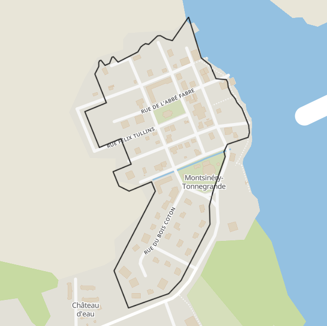
Périmètre Opération Programmée d'Amélioration de l'Habitat (OPAH) 2025-2030 - Montsinéry-Tonnegrande
Périmètre de l'Opération Programmée pour l'Amélioration de l'Habitat (OPAH) sur la commune de Montsinéry-Tonnegrande (secteur centre-bourg de Montsinéry), portant sur la période 2025-2030.
Simple
- Date (Creation)
- 2025-08-28
- Identifier
- a47b27f6-5fb0-4528-95eb-69010de02df9
- GEMET - INSPIRE themes, version 1.0
-
- Étendue géographique des données
- Theme
-
- Montsinery-Tonnegrande
- OPAH
- Urbanisation
- Habitat
- Access constraints
- otherRestrictions Other restrictions
- Spatial representation type
- vector Vector
- Metadata language
- freFrançais
- Topic category
-
- amenagement-et-urbanisme
- equipements-batiments-et-logement
- OnLine resource
-
perimetre-operation-programmee-d-amelioration-de-l-habitat-opah-2025-2030-montsinery-tonnegrande
(
OGC:WMS
)
None
- OnLine resource
-
perimetre-operation-programmee-d-amelioration-de-l-habitat-opah-2025-2030-montsinery-tonnegrande
(
OGC:WFS
)
None
- Hierarchy level
- dataset Dataset
- Statement
- Numérisation vectorielle à partir de la cartographie du périmètre d'intervention présente dans la convention de l'OPAH, en reprenant la géométrie des parcelles cadastrales concernées.
- File identifier
- a47b27f6-5fb0-4528-95eb-69010de02df9 XML
- Metadata language
- freFrançais
- Hierarchy level
- dataset Dataset
- Date stamp
- 2025-08-28
- Metadata standard name
- INSPIRE Metadata Implementing Rules
- Metadata standard version
- Technical Guidelines based on EN ISO 19115 and EN ISO 19119 (Version 1.2)